
搜索结果: 1-15 共查到“Detection”相关记录387条 . 查询时间(0.346 秒)

Brown researchers develop new, automated, powerful diagnostic tool for drug detection(图)
药物检测 诊断工具 生物医学 抗抑郁药
2023/6/26
The work by a research team made up largely of Brown graduate and undergraduate students addresses a critical biomedical need and has the potential to be widely adapted by clinicians to monitor antide...
Academy of Mathematics and Systems Science, CAS Colloquia & Seminars:A LASSO-based Detection and Identification Method on Actuator Integrity Attacks in Remote Control Systems
LASSO 远程控制系统 执行器 完整性 攻击检测 识别方法
2023/4/28
We consider actuator attacks in a remote control system. Compared with sensor attacks that have been studied in most existing literature, the malicious attacks over actuators can cause more disastrous...
AUTOMATED BUILDING DETECTION IN DENSE POINT CLOUD AND UPDATE OF OPEN SOURCE DATA BASES
Dense matching, Building detection Classification Digital Terrain Model openstreetmap point cloud
2018/11/9
In this paper a method of detecting buildings in dense populated city areas using a three-dimensional model, produced by aerial images, is described. Further to the detection of the outline of the bui...
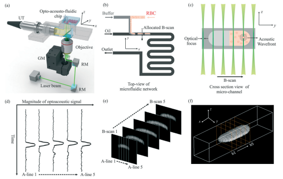
中国地质大学科学技术发展院宋潮龙等机电学院, Lab on a Chip, 27 March 2018. Opto-acousto-fluidic microscopy for three-dimensional label-free detection of droplets and cells in microchannels(图)
荧光剂;纳米颗粒;实现;物质;检测;分析
2021/10/21
2018年3月27日,微流控领域国际顶级期刊《Lab on a Chip》刊发了中国地质大学机电学院宋潮龙教授的最新研究成果:“Opto-acousto-fluidic microscopy for three-dimensional label-free detection of droplets and cells in microchannels”,该论文被推荐为封面文章。
INFRARED ROTATION PLANE RADAR CHANGE DETECTION
Infrared Rotation Plane Radar Change Detection Depth Information Mixed Gaussian Background Modeling
2018/5/15
The existing change detection method mainly stays on the pixel-level, which is very susceptible to light, shadow, etc. And the complex calculation and analysis for each pixel reduce the detection effi...
THE FEASIBILITY EVALUATION OF LAND USE CHANGE DETECTION USING GAOFEN-3 DATA
GaoFen-3 Change Detection Land Use Polarimetric SAR High-resolution Quality Evaluation
2018/5/14
GaoFen-3 (GF-3) satellite, is the first C band and multi-polarimetric Synthetic Aperture Radar (SAR) satellite in China. In order to explore the feasibility of GF-3 satellite in remote sensing interpr...
THIN CLOUD DETECTION METHOD BY LINEAR COMBINATION MODEL OF CLOUD IMAGE
Cloud Detection Image Features Grayscale Texture Linear Model AdaBoost Classifier
2018/5/15
The existing cloud detection methods in photogrammetry often extract the image features from remote sensing images directly, and then use them to classify images into cloud or other things. But when t...
STUDY ON CLASSIFICATION ACCURACY INSPECTION OF LAND COVER DATA AIDED BY AUTOMATIC IMAGE CHANGE DETECTION TECHNOLOGY
National Geographic Conditions Monitoring Land Cover Data Quality Inspection Classification Accuracy Change Detection
2018/5/16
The purpose of carrying out national geographic conditions monitoring is to obtain information of surface changes caused by human social and economic activities, so that the geographic information can...
DEEP CONVOLUTIONAL NEURAL NETWORK FOR AUTOMATIC DETECTION OF DAMAGED PHOTOVOLTAIC CELLS
UAV, monitoring/inspection Anomaly Detection Deep Learning Photovoltaic Panels Thermography Classification
2018/6/4
The number of distributed Photovoltaic (PV) plants that produce electricity has been significantly increased, and issue of monitoring and maintaining a PV plant has become of great importance and invo...
DEEP LEARNING AND IMAGE PROCESSING FOR AUTOMATED CRACK DETECTION AND DEFECT MEASUREMENT IN UNDERGROUND STRUCTURES
Deep Learning Automated Crack Detection Photographic Tunnelling Surveys
2018/6/4
This work presents the combination of Deep-Learning (DL) and image processing to produce an automated cracks recognition and defect measurement tool for civil structures. The authors focus on tunnel c...
SEMANTIC SEGMENTATION AND UNREGISTERED BUILDING DETECTION FROM UAV IMAGES USING A DECONVOLUTIONAL NETWORK
Deep learning UAV image segmentation building detection illegal buildings
2018/6/4
Detecting unregistered buildings from aerial images is an important task for urban management such as inspection of illegal buildings in green belt or update of GIS database. Moreover, the data acquis...
RAPID OBJECT DETECTION SYSTEMS, UTILISING DEEP LEARNING AND UNMANNED AERIAL SYSTEMS (UAS) FOR CIVIL ENGINEERING APPLICATIONS
Object detection Deep Learning Unmanned Aerial Systems Railway, Rapid
2018/6/4
With deep learning approaches now out-performing traditional image processing techniques for image understanding, this paper accesses the potential of rapid generation of Convolutional Neural Networks...
3D BUILDING CHANGE DETECTION BETWEEN CURRENT VHR IMAGES AND PAST LIDAR DATA
Change detection LiDAR data VHR images DSM Quality Disparity MRF Optimization
2018/6/5
Change detection is an essential step to locate the area where an old model should be updated. With high density and accuracy, LiDAR data is often used to create a 3D city model. However, updating LiD...
URBAN AREA CHANGE DETECTION USING TIME SERIES AERIAL IMAGES
Photogrammetry Dense Point Cloud Aerial Image Historical Image Urban Change Detection
2018/6/4
The urban area should be imaged in three-dimensional (3D) for planning, inspection and management. In addition fast urbanisation requires detection the urban area changes which have been occurred with...
OBJECT-ORIENTED CLASSIFICATION OF LIDAR DATA FOR POST-EARTHQUAKE DAMAGE DETECTION
LiDAR Earthquake Classification Object Oriented Image Analysis Buildings Damage Detection
2018/5/8
The collapse of buildings during the earthquake is a major cause of human casualties. Furthermore, the threat of earthquakes will increase with growing urbanization and millions of people will be vuln...